
Introduction: Pioneering Antarctic Exploration

In a groundbreaking mission to delve into the mysteries of Antarctica, a team of scientists and engineers has set foot on the icy terrain to test a revolutionary drone. This autonomous aircraft is poised to revolutionize our understanding of the continent and aid in forecasting the impacts of climate change. The drone is designed to access areas that were previously inaccessible to researchers, marking a significant leap forward in Antarctic exploration.
The challenges of conducting research in Antarctica are formidable, with the harsh environment presenting obstacles for traditional methods. Strong winds, sub-zero temperatures, sudden storms, and the logistical constraints of transporting pilots and fuel have limited the scope of exploration. In response to these challenges, the British Antarctic Survey, in collaboration with UK company Windracers, has developed an innovative drone that promises to overcome these barriers. Tested in extreme conditions around Wales’ highest peaks, this autonomous aircraft has demonstrated its capacity to withstand the adverse weather conditions synonymous with Antarctica. Its primary mission will be to survey the mountains concealed beneath the Antarctic ice sheet, providing crucial insights into the rate of ice melt and its implications for global sea-level rise.
Revolutionizing Antarctic Exploration
This innovative drone has successfully weathered extreme conditions around Wales’ highest peaks during testing, demonstrating its robustness and reliability in adverse environments. This achievement serves as a testament to its capability to operate seamlessly in the challenging conditions synonymous with Antarctica. The primary mission of this groundbreaking autonomous aircraft is to survey the mountains concealed beneath the Antarctic ice sheet.
By venturing into areas previously inaccessible to researchers, the drone aims to provide invaluable insights into the rate of ice melt and its significant contribution to global sea-level rise. Antarctica’s vast and largely uncharted topography is a critical factor in understanding the dynamics of ice sheets. The drone, equipped with state-of-the-art instruments including radar and cameras, is poised to unveil the hidden landscape beneath the ice. This comprehensive survey work is essential for building more accurate models of global sea-level rise and improving our understanding of how Antarctica’s complex terrain influences the pace of ice melting, thereby aiding in more precise climate change predictions.
Challenges of Traditional Research Methods
Traditional research methods encounter significant impediments in Antarctica’s harsh environment, marked by formidable challenges such as strong winds, sub-zero temperatures, and unpredictable storms. Crewed planes, a staple in conventional exploration, grapple with limitations imposed by safety concerns, the prolonged darkness of Antarctic winters, and logistical hurdles related to transporting pilots and substantial fuel quantities. However, heralding a new era in polar research, the British Antarctic Survey, in collaboration with the UK company Windracers, has developed an innovative drone poised to revolutionize the way scientists explore the frozen continent. This drone represents a groundbreaking solution, adept at overcoming the formidable obstacles that have historically restricted the scope of scientific endeavors in Antarctica.
Advanced Features and Capabilities
Engineer Rebecca Toomey, in the midst of a practice run amidst adverse weather conditions, shed light on the remarkable capabilities of the drone. This autonomous aircraft, designed with ingenuity, possesses the remarkable capacity to carry a payload of up to 220lb (100kg) and traverse distances of up to 620 miles (1,000km). Such capabilities position the drone as an invaluable asset for reaching and exploring remote areas of Antarctica without exposing human pilots to potential safety risks.
Loaded with cutting-edge instruments, including advanced radar and high-resolution cameras, the drone’s capabilities extend beyond its transport function. The route of the drone is meticulously pre-programmed, ensuring precise navigation through the challenging Antarctic terrain. Moreover, the entire flight is closely monitored by an engineer operating from the comfort and safety of a computer station. This seamless integration of technology not only enhances the efficiency of data collection but also minimizes the risks associated with traditional crewed flights in the treacherous Antarctic conditions.
Operational Advantages: A Greener Approach
Operated initially from the Rothera base in Antarctica under the skilled guidance of Engineer Rebecca Toomey, the British Antarctic Survey harbors ambitious plans to eventually launch the drone from the UK. This strategic vision reflects not only the drone’s adaptability to diverse operational bases but also underscores its potential to revolutionize the accessibility of Antarctic exploration. The prospect of flying the drone from the UK signals a paradigm shift in scientific research capabilities, transcending geographical constraints and expanding the reach of cutting-edge technology.
Beyond its groundbreaking operational flexibility, the drone champions environmental sustainability. In stark contrast to traditional planes, the drone is engineered to operate on significantly less fuel, presenting a noteworthy reduction in the ecological footprint associated with scientific research. This commitment to minimizing environmental impact aligns seamlessly with the broader goals of sustainable scientific exploration, further establishing the drone as a pioneering tool in advancing our understanding of Antarctica’s intricate ecosystem while ensuring responsible research practices.
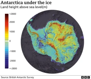
Mapping the Uncharted
Antarctica’s topography remains largely uncharted, with vast expanses of the continent yet to be explored due to the challenging conditions. The drone’s data collection will be instrumental in creating a more detailed model of the continent, known as BEDMAP2, revealing the complex landscape hidden beneath the ice.
Scientific Significance: Filling in the Blanks
Scientist Tom Jordan underscores the significance of this survey work, describing it as an opportunity to fill in the blanks on the map. Large portions of Antarctica, including massive mountain ranges and valleys, have never been mapped. Understanding this topography is crucial for predicting how quickly ice will melt in response to warming waters.
Unveiling the Hidden Landscape
In its maiden experiment, the drone will deploy radar to fire radio waves at the Fuchs Piedmont ice sheet. By measuring the reflections of these waves bouncing off the ground, the drone will create a detailed picture of the land underneath. This critical data will enhance current models of global sea-level rise, allowing scientists to make more accurate predictions and plan for the future effectively.
Conclusion: A New Chapter in Antarctic Exploration
As this cutting-edge technology takes flight over Antarctica, it promises to unlock the frozen continent’s secrets and provide a clearer picture of its role in the global climate system. The first flights of the drone are expected in the coming weeks, with additional experiments planned to survey marine life, including krill, and environmentally sensitive areas. Antarctica stands at the brink of a new chapter in exploration, with technology leading the way to uncover the secrets hidden beneath the ice.
Related Topics
- Unprecedented Ocean Heating Raises Alarming Concerns: A Glimpse into a World 3.0°C Warmer – Micro2media
- Unveiling the Intersection of Ecology, Health, and AI – Micro2media
- Environment News, Earth News, Global Warming, Wild Life, Carbon Trading, Climate Business, Climate Change & Pollution News
- Antarctica mysteries to be mapped by robot plane – BBC News